A small rock in the Atlantic

All about the island of La Palma, in the Canaries.

Click for La Palma, Canary Islands Forecast

Friday, 21 November 2008

Spot the Lava Flow

Lava flow in El Paso, La Palma.
Just north of Fatima, El Paso

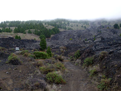
Ladies and gentlemen, can you spot the lava flow in this picture?

This lava flow at Fatima in El Paso is from the eruption of Volcan San Juan (St. John's volcano) in 1949, but the whole island is volcanic. And, geologically speaking, it's still in nappies.

The very oldest rocks on the island formed as a submarine volcano, some 3 three million years ago. Of course most of it's buried deep, but if you know where to look, there's a little patch of it you can see in the Barranco de las Angustias (the big ravine that drains the Caldera). Apart from that, the northern end is the oldest, at a mere 1,500,000 years old. Most of the south is younger, at 700,000 years old, give or take. And just to confuse the tourists, the Cumbre Vieja (old ridge) is younger than the Cumbre Nueva (New Ridge).

And the youngest bit of the island is Playa Nueva which means (very) New Beach. It was formed when Teneguía erupted from October 26th to November 28th in 1971. It's just 37 years old - younger than I am. Luckily the eruption only killed one person, an old man who got too close and suffocated. My husband was a teenager and remembers it well. You could here the rumbling from Breña Baja, and the whole family went to see the show from the higher volcano of San Antonio.

Today, plants are just beginning to colonise the area near the cone, and the red rocks make the surrounding area look like Mars (See Which Planet Are You On? ).

Labels: , , , , , , ,

Bookmark with:

Del.icio.us Digg Reddit Facebook Furl It Newsvine StumbleUpon ToolbarStumbleUpon

Monday, 17 November 2008

The Tsunami Risk

You may remember the fuss in 2001 when two geologists, Steven Ward and Simon Day, announced their theory that the west side of the island of La Palma would collapse one day, creating a mega-tsunami that would cross the entire Atlantic and still be anything up to 25 metres high when it hit New York, and indeed everything from Newfoundland in Canada to Recife in Brazil.

These days, almost all geologists seem to disagree.

Certainly there is a fault line, and some movement has been detected, but the fault appears to be 4 km long, not 25 km. There is no evidence that it's 2 km deep, so any landslide would be superficial and might not happen all at once. There's a volcano, but it's comparatively small. And there's a lot of water inside the island, but if the volcano erupts and turns it to steam, it has lots and lots of escape routes through the porous lava. Therefore it won't push the rock into a landslide.

The tsunami that did such awful damage in December 2004 was caused by an earthquake along 1,000 km of sea bed. If a landslide does happen on La Palma, it couldn't possibly be longer than 25 km, so the tsunami will weaken as it spreads out. You'd hardly get a splash the other side of the Atlantic.

By the way, the research was paid for by an American insurance company. And it wasn't published in a peer-reviewed journal, which means that other scientists didn't get chance to give opinions before it was broadcast.

My opinion? It's a load of hype.

You can read more at: http://www.lapalma-tsunami.com/tsunami.html
and http://www.iberianature.com/material/megatsunami.html

Labels: , , , ,

Bookmark with:

Del.icio.us Digg Reddit Facebook Furl It Newsvine StumbleUpon ToolbarStumbleUpon